SEI's Digital Library
SEI manages our entire seismic library in a completely digital enviornment, the culmination of years of effort assimilating over 100 datasets.
Our 2D Digital Library
-
2D processed and field data is stored live on SEI's network, converted from countless analog and magnetic tapes.
-
2D seismic sections are created real-time from SEGY data, when requested for QC or ordered. Legacy versions, scanned from hundreds of thousands of paper and mylar prints are also stored live on SEI's network.
-
All key support data has been catalogued and converted into electronic/digital database records. Thousands of boxes of original paper support documents have been scanned and are order ready.
-
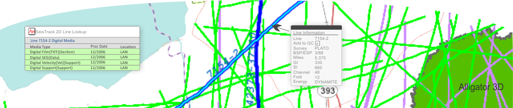
Shape data, created from the geometry files for each line, is displayed on SEI's ESRI based interactive web mapping application, accessible to all clients from this website. Digital SEGP1 data is provided for all orders and as requested by clients.
Our 3D Digital Library
-
3D processed, pre-processed and field data are stored nearline on a robotic tape library and recalled to live storage for order processing, converted from thousands of boxes of magnetic tapes.
-
All key support data has been catalogued and converted into electronic/digital database records. The original support files, generally created in a digital format, are order ready.
-
Shape data, created from the geometry files for each 3D survey, is displayed on SEI's ESRI based interactive web mapping application, accessible to all clients from this website. Shape files are provided for all orders and as requested by clients.
SEI has made and continues to make strategic investments in technology to optimize our digital data management capabilities.
SeisTrack
SEI uses SeisTrack, our in-house developed internet based software application, to manage our entire library. With SeisTrack, our staff has real time knowledge of every seismic line or survey in our library, along with all related media and metadata. It has allowed us to continually improve speed, efficiency and accuracy for our data management and order processing functions.
ESRI Based Mapping
SEI maintains all SEGP1 coordinates and shape files in its Oracle mapping database which serves an array of SEI's custom developed applications that use ESRI technology to handle everything from the interactive WebMap application on this website to order fulfillment.
Infrastructure
We continue to invest in our technology infrastructure to manage petabytes of seismic data, including EMC Isilon NAS equipment and a Spectra Logic automated tape library system. This investment has allowed us to transition our data management and data delivery functions from physical to digital.
Bottom line, SEI's digital library makes it easier for our clients to find the seismic data they are looking for, to order the exact versions they need and to receive their orders quickly and accurately.